NLS has a new mapping project on line in which historic maps of Edinburgh are georeferenced, which I think is a fancy way of saying the old maps are overlaid on contemporary Google maps.
http://geo.nls.uk/urbhist/index.html
There are currently a few maps covering Porty in the examples section.
The site is very slow at the moment, but hopefully that's down it being new and thus very busy.
Historic Maps of Edinburgh

Re: Historic Maps of Edinburgh
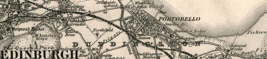
The NLS have just added a big batch of 2nd edition, and later, OS six-inch maps. Here are some Portobello sheets:wangi wrote:Bob Jefferson wrote:I particularly like the historical map image btw.
It's an excerpt from the 1898 Ordnance 2nd Edition Survey One-inch to the mile map; see: http://maps.nls.uk/os/view/?sid=74488700
The National Library of Scotland now have a lot of interesting historical maps at: http://maps.nls.uk/
Edinburghshire Sheet IV.NW; 1938
Edinburghshire Sheet IV.NW; 1932
Edinburghshire Sheet IV.NW; 1913
Edinburghshire Sheet IV.NW; 1905
Edinburghshire Sheet IV.NW; 1894
Lots of change between the years as Portobello gets swallowed up by Edinburgh. And note the moving park / GC between 1894 and 1905.

L/
Re: Historic Maps of Edinburgh
And the 1893-4 1:500 large scale town plan is rather nice: http://geo.nls.uk/maps/towns/portobello/openlayers.html
-
Bob Jefferson

- Posts: 6212
- Joined: 11 Dec 2004, 21:16
- Location: Planet Porty
- Contact:
Re: Historic Maps of Edinburgh
Great find. I'm puzzled by that 1893-4 map though. Portobello seems to be way ahead in the automotive industry.